Map.
Analyze.
Build.
We are a GIS-focused technology
firm that performs spatial analysis
and develops software solutions
for the resort & hospitality world.
SPATIAL ANALYSIS /
We specialize in the acquisition and management of high-quality geospatial data to support your projects. From sourcing satellite imagery to organizing large datasets, we ensure that your geospatial information is accurate, accessible, and secure. Our expertise in data structuring, cleaning, and integration enables seamless workflows, ensuring that your data remains a valuable asset throughout the lifecycle of your project.
Our habitat and environmental modeling services provide a scientific approach to understanding ecosystems and predicting environmental changes. Using advanced GIS technologies, we analyze habitat suitability, simulate ecological processes, and forecast environmental impacts. These models support biodiversity conservation, resource management, and regulatory compliance, empowering stakeholders to make science-based decisions that protect and sustain natural resources.
Our environmental planning and analysis service offerings help clients navigate the complexities of land use, natural resource management, and environmental compliance. We assess environmental impacts, model future scenarios, and provide actionable insights for sustainable development. Our solutions support informed decision-making, enabling organizations to evaluate potential risks and optimize their operations in line with regulatory requirements. Whether managing conservation efforts, conducting environmental assessments, or planning for future growth, we deliver precision-driven strategies to foster responsible environmental stewardship.
We provide advanced wildfire hazard modeling and risk assessments to help clients understand and mitigate fire-related risks. Using state-of-the-art spatial modeling techniques, we analyze fire behavior, map hazard zones, and identify vulnerabilities in infrastructure and natural landscapes. Our services enable proactive planning, emergency preparedness, and informed decision-making, ensuring safety and resilience in the face of wildfire threats.
Site suitability and optimization models help clients identify the best locations for development, conservation, or resource management. Using advanced GIS tools and spatial analysis, we evaluate a variety of factors such as environmental conditions, infrastructure accessibility, and regulatory constraints to determine optimal site selection. Our data-driven models provide clear insights into site potential, allowing for more efficient planning and decision-making. Whether you're assessing land for development, zoning, or infrastructure projects, our solutions ensure you choose the most suitable and sustainable sites for success.
We offer comprehensive site and volumetric analysis to help clients assess land suitability and optimize development projects. Using advanced GIS and 3D modeling techniques, we analyze topography, volume calculations, and spatial relationships to inform design decisions and minimize risks. Our solutions provide detailed insights into site conditions, helping to identify challenges and opportunities for efficient land use. Whether planning for construction, infrastructure, or natural resource management, our data-driven approach ensures accurate, actionable analysis for successful project outcomes.
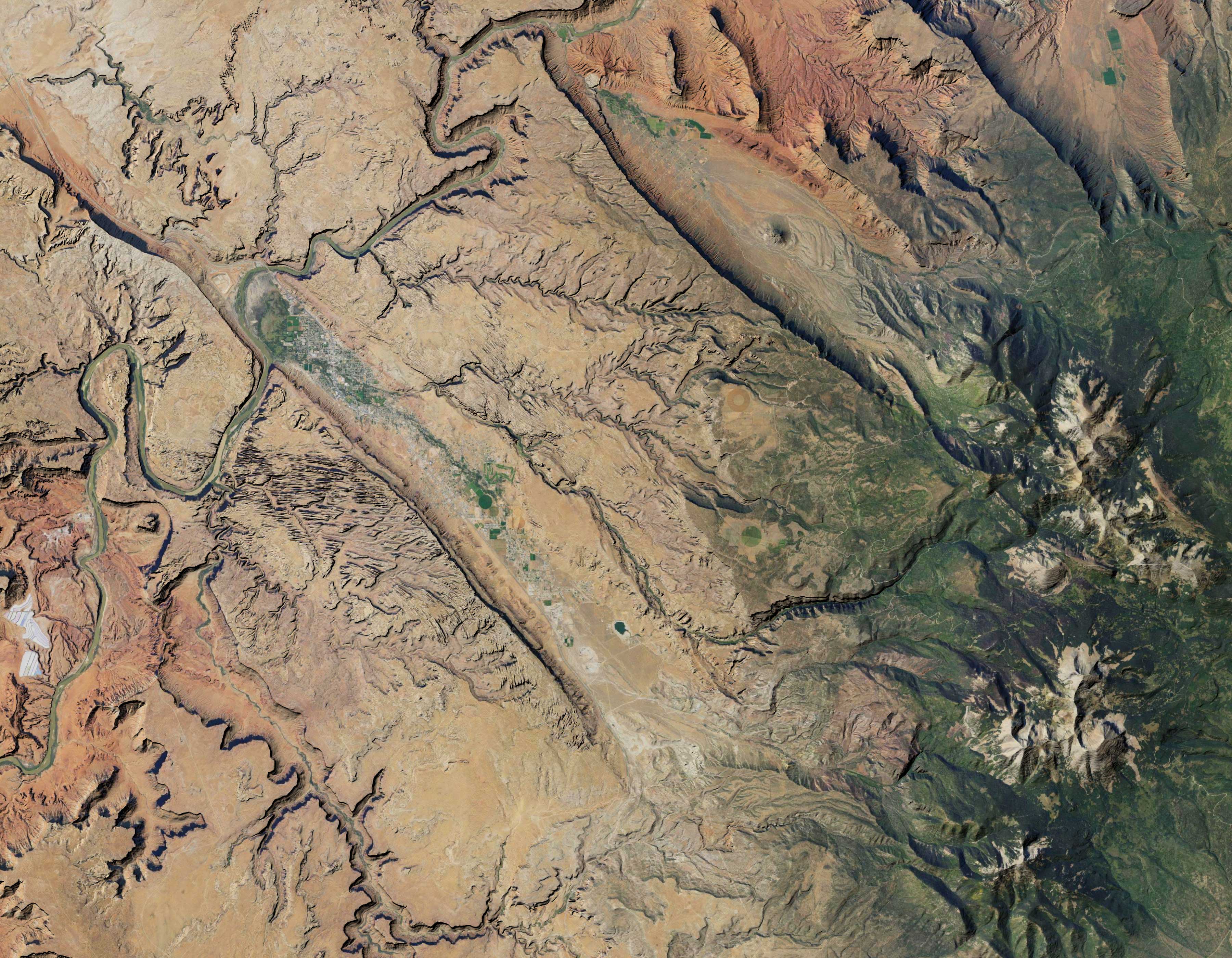
We provide advanced imagery analysis to extract valuable insights from satellite and aerial imagery. Leveraging powerful GIS tools and remote sensing technologies, we analyze visual data to assess land cover, monitor environmental changes, and identify patterns in infrastructure development. Our solutions enable precise decision-making by transforming raw imagery into actionable intelligence. Whether for environmental monitoring, urban planning, or disaster response, our imagery analysis services help you gain a deeper understanding of the landscape and make informed, timely decisions
GEOSPATIAL SERVICES
At ELEV8, we believe that data should drive decisions. We harness the power of GIS to transform how you understand and interact with the world around you, applying our expertise to analyze complex spatial datasets, model potential scenarios, and visualize data in compelling ways. Our goal is to develop innovative solutions that empower you with the knowledge you need to address your unique challenges and deliver measurable results that achieve your objective with precision.
Data Acquisition & Management
Habitat & Environmental Modeling
Environmental Planning & Analysis
Wildfire Hazard Modeling & Risk Assessments
Site Suitability & Optimization Modeling
Site & Volumetric Analysis
Imagery Analysis
MAPPING /
We craft print maps that are more than just geographic representations, they're works of art. Our cartographic design service blends technical precision with artistic vision, resulting in visually stunning and informative maps tailored to your specific needs. Whether for reports, presentations, or display, our print maps communicate your message with clarity and elegance, leaving a lasting impression
Bring your data to life with interactive and dynamic web maps. Our web mapping service develops custom solutions that empower users to explore, analyze, and interact with geographic information. From simple embedded maps to complex web applications with advanced functionality, we create online mapping experiences that are both informative and user-friendly, providing real-time access to critical insights.
Tell your story through the power of place. Our story map service combines compelling narratives with interactive maps and multimedia elements to create immersive and engaging experiences. Whether showcasing research findings, highlighting community initiatives, or promoting tourism destinations, our story maps captivate your audience and communicate your message with clarity and impact.
Explore your data from a new perspective with our 3D modeling and visualization service. We create immersive 3D environments that bring geographic data to life, offering unique insights and perspectives. From visualizing urban landscapes to modeling terrain and natural resources, our 3D visualizations transform complex data into compelling visuals that inform, inspire, and drive understanding."
MAPPING SERVICES
We create maps and compelling visuals that tell stories and resonate with your audience. Our cartographic services offer beautifully designed print maps, interactive and dynamic web experiences, captivating story maps and immersive 3D visualization. We blend technical expertise with artistic vision to deliver mapping solutions that inform, engage and inspire.
Cartographic Design & Print Maps
Web Mapping & Interactive Maps
Story Maps
3D Mapping & Visualization
DEVELOPMENT /
We leverage cutting-edge technologies and innovative approaches to build intelligent, map-centric software applications that transform your workflows and empower data-driven decision-making. From streamlining operations to improving decision-making, we leverage the power of mapping, spatial analysis, and location data to deliver solutions designed to optimize your performance and empower you to make smarter decisions, faster.
Our mobile application development services put the power of location intelligence in the palm of your hand. We develop cross platform mobile applications that provide real-time access to critical spatial data and enable on-the-go decision-making. Whether you need field data collection tools, location-based services, or interactive mapping experiences, our mobile apps are designed to be intuitive, user-friendly, and seamlessly integrated with your other systems.
Our API development services empower organizations to integrate GIS capabilities directly into their existing systems and workflows. We design and build custom APIs that facilitate seamless data sharing, advanced spatial analysis, and integration with other software and platforms. These APIs enable real-time access to critical location-based data, fostering collaboration and enhancing decision-making across teams. At ELEV8, we develop APIs to provide the flexibility and power you need to maximize the value of your geospatial information.
DEVELOPMENT SERVICES
Our expertise extends beyond mapping and spatial analysis to the creation of dynamic, location-aware web and mobile applications. We craft intelligent, location-aware software solutions tailored to your specific needs and built to integrate seamlessly into your workflows. From web and mobile applications to seamless API integrations, we leverage the power of mapping, spatial analysis, and location data to create tools that streamline your workflows, enhance collaboration, and empower data-driven decision-making.
Custom Software Development
Mobile Application Development
API Development & Integration
INDUSTRIES /
We support a wide range of clients in diverse business sectors, delivering tailored GIS solutions that help organizations navigate complex challenges and optimize outcomes.
Energy, Utilities & Telecommunications
Environmental & Natural Resources
Emergency Management
Architecture & Planning
Construction & Engineering
Real Estate & Land Development
Resort & Hospitality
Recreation & Tourism
Agriculture & Forestry
Local, State & Federal Government
INDUSTRIES & BUSINESS SECTORS
Your next journey starts here.
CONTACT /
Your next journey starts now.
Let's take it together.

Map out your next move.


We're here to help you reach your destination.

Let's Talk
CONTACT US